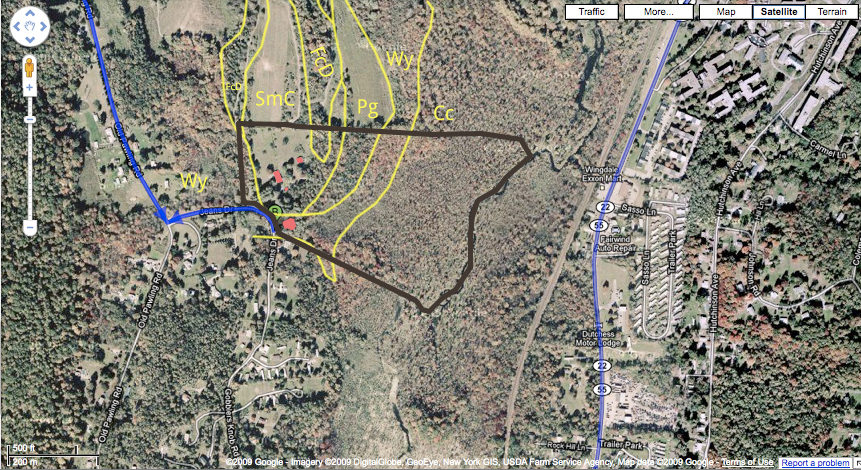
Using a Soil Survey of Dutchess County, NY, we made an overlay of soil types with a google maps pic. The brown outline is the property line; the pink boxes are the house/barn/etc.; the bright blue is the pond.

Here’s a brief explanation of what the letters mean (overall the soil survey averages about 20% exceptions within the labeled areas – obviously once we get out to the land and start digging around we’re going to find out how well these definitions hold up):
- Cc – Carlisle Muck: wet/floods (in our case, within the 100 year flood zone) – use for woodlands
- Wy – Wayland silt loam (nearly level): wet/floods – use for woodlands
- Pg – Pawling silt loam (nearly level): prime farmland 1.5-2 ft. seasonal high water table (rooting zone restricted by this); moderately acidic; bedrock more than 60 inches; occasional flooding in early spring (use cover crops and sod crops)
- SmC – Stockbridge-Farmington complex, rolling, rocky. Stockbridge soils are commonly on lower concave slopes and Farmington soils are commonly on hilltops, upper slopes, and near areas of rock outcrop. Slopes are complex and range from 5 to 16 percent. Bedrock past 80 inches or at 15 inches. more than 6 feet to high water table. Most areas of this unit are used for cropland or pastureland. Other areas are used for woodland or residential development. Suited to cultivated crops.
- FcD – Farmington-Galway complex, hilly, very rocky. Farmington soils are commonly on upper slopes and near areas of rock outcrop and Galway soils are commonly on lower concave slopes. Bedrock 15-31 inches. Used for woodland, pasture, residential.
We took soil samples (for nutrient testing), and the soil tended toward clay but didn’t seem rocky at all. I also didn’t notice any rock outcroppings.
